


GPS Waypoints
Description of GPS Waypoints
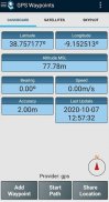
GPS Waypoints is a mobile application designed for outdoor enthusiasts, surveyors, and anyone interested in mapping and navigating their surroundings. This app enables users to acquire their current position with high accuracy and provides essential navigation information. Available for the Android platform, GPS Waypoints can be easily downloaded to facilitate a range of location-based activities.
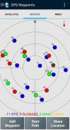
The application offers a variety of features that enhance the user experience when collecting geographical data. Users can view details about active and visible satellites, including GPS, GLONASS, GALILEO, and BEIDOU. This satellite information helps improve positioning accuracy, making it a valuable tool for precise navigation tasks.
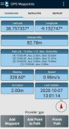
One of the standout functionalities of GPS Waypoints is its ability to create Points. Users can capture geographical locations with accuracy information, classify them using Tags, and attach photos for better context. Additionally, the app includes reverse geocoding capabilities, allowing users to convert coordinates into human-readable addresses, making the data more accessible and informative.
The app also facilitates the importation of Points through geographic coordinates or by searching for a street address or point of interest. This geocoding feature allows for seamless integration of existing data into the app, enhancing the user’s ability to manage their location information effectively.
Creating Paths is another core function of GPS Waypoints. Users can acquire sequences of points manually or automatically to record tracks over time. This feature is particularly useful for those who wish to document their journeys, whether for personal records or professional surveying tasks. Furthermore, users can import existing Points to create new Paths, providing a flexible approach to mapping activities.
Custom Tags can be used to create survey themes, allowing users to classify Points and Paths according to their specific needs. This organizational capability enhances the app’s utility, making it easier for users to retrieve and analyze their data. The app supports sorting and filtering by creation time, name, and proximity, which can streamline the management of extensive datasets.
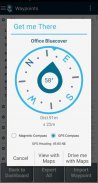
For navigation purposes, GPS Waypoints provides directions and distances from the current position to selected Points and Paths. Users can utilize either a magnetic or GPS compass to facilitate their navigation, ensuring they have reliable tools at their disposal for outdoor activities.
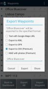
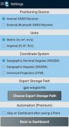
Exporting data is a key feature, with the app allowing users to export Points and Paths in KML and GPX file formats. This functionality is crucial for users who wish to process their collected data externally using geospatial tools. Additionally, Points and Paths can be exported to CSV format, and users can export Waypoints with photos to KMZ files, further enhancing data sharing capabilities.
The Premium subscription offers advanced features that cater to professional users. One of the benefits of the Premium version is the ability to backup and restore user data, which also facilitates data transfer from one device to another. This feature is essential for users who may upgrade or change devices and want to retain their important location information.
Another valuable aspect of the Premium subscription is the ability to import multiple Points and Paths from CSV and GPX files, making it easier to integrate large datasets. Users can also engage in satellite signal analysis and detect interferences, providing insights into the reliability of their connections.
The app includes a paid Maps feature that allows users to visualize their Points, Paths, and Polygons on Open Street Maps. This additional functionality provides a comprehensive view of location data in a familiar mapping interface, enhancing the overall user experience.
GPS Waypoints is compatible with various external receivers, including Bad Elf GNSS Surveyor, Garmin Glo, Navilock BT-821G, Qstarz BT-Q818XT, Trimble R1, and ublox F9P. This compatibility ensures that users can select the best hardware to suit their specific needs and preferences.
The application is ideal for those involved in mapping and surveying, as it provides essential tools for collecting, analyzing, and sharing geographical data. Its combination of features allows users to navigate effectively, document their journeys, and manage their location information in a structured manner. The ability to export data in multiple formats further enhances its usability for professional applications, making GPS Waypoints a robust solution for outdoor navigation and data collection.
For further information, visit our site at https://www.bluecover.pt/gps-waypoints to explore the complete range of features and offerings available with GPS Waypoints.
GPS Waypoints - Version 3.13
(02-12-2024)GPS Waypoints - APK Information
APK Version: 3.13Package: pt.bluecover.gpsegnosLatest Version of GPS Waypoints
Other versions


Apps in the same category

You may also like...


